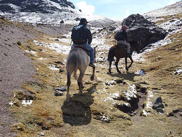
There are some adventures that are just calling my name, and the 5-day trek to Choquequirao is firmly at the top of my list. I know it’s a challenging experience, a 40-mile round-trip journey that’s definitely not for the faint of heart, but that’s exactly what draws me in. This is more than just a hike; it’s a chance to explore the sacred sister of Machu Picchu, a unique Inca city perched dramatically above the Apurímac Canyon. I’m fascinated by the idea of standing before what the locals call the “Speaking God,” the mighty river flowing below.
This trek feels like a true pilgrimage. The route itself was once a religious and ceremonial path designed to honor the sacred mountains looming in the Salkantay range, like the Apus Yamana, Ampay, and Chokecarpu. I can’t wait to visit this “Last Refuge of the Inca Empire,” situated over 9,940 feet (3,030 meters) above sea level. I’m desperate to see its complex hydraulic systems and understand its role as an Inca enclave connected to Machu Picchu by a network of ancient roads. It’s the raw, untouched nature of Choquequirao that I’m craving—an epic, rewarding adventure that promises an incredible sense of discovery.
The trip will kick off with a pickup from my hotel in Cusco (11,152 ft / 3,399 m). We’ll travel by private transport to the beautiful Andean village of San Pedro de Cachora (9,186 ft / 2,800 m). From Cachora, the real journey begins with a 4-hour hike before we stop for lunch. Afterwards, we’ll head towards the Kapuliyoq sector. I’m excited for this part of the trek, as I’ve heard the landscapes are incredibly diverse, with views of the snow-capped Padriyoc peak and all kinds of Andean flora and fauna.
This is where I’ll get my first look at the Apurímac Canyon—the deepest in the world—and maybe even catch a glimpse of Choquequirao itself in the distance. We’ll continue descending to Chiquisca (6,266 ft / 1,910 m) for a short break. After lunch, a final 2-hour descent will take us to our campsite for the night, La Playa, situated at about 5,905 feet (1,800 m) near the sacred Apurímac River. It sounds like the perfect way to up the step count and finish the first day.
After an organic breakfast, today’s challenge is the climb. It starts with a 2-hour ascent to the small village of Santa Rosa, which will be a welcome rest stop. Then, it’s another 3 hours uphill to our lunch spot in Marampata (9,678 ft / 2,950 m). I imagine the views of the Apurímac Canyon, the Choquequirao mountain, and the surrounding majestic peaks will be absolutely stunning and make the effort worthwhile. After lunch, the hike becomes much gentler as we make our way to the lost city of the Incas, Choquequirao. The camp is located just outside the archaeological site, which sounds perfect. I’m hoping to catch an incredible sunset and maybe even see some condors.
Today is all about exploring the magnificent archaeological site of Choquequirao from top to bottom. I can’t wait for the private guided tour to discover all the beautiful sections of this incredible city: the temples, terraces, palaces, and the famous llama-adorned walls. We’ll be returning to the same campsite for tea and to spend the night.
Choquequirao, meaning “Cradle of Gold” in Quechua, is another “Lost City of the Incas” that was only officially rediscovered in the late 20th century. It sits at a staggering elevation of nearly 5,741 feet (1,750 meters) above the thundering, glacier-fed Apurímac River, surrounded by the looming, snow-capped Salkantay and Humantay mountains. What’s wild is that only an estimated 30% of the 1,810-hectare site has been restored, and archaeologists are uncovering new areas every day. Getting my history fix here will be an absolute highlight.
This morning, we start our trek back towards Santa Rosa, where we’ll have lunch. Afterwards, we’ll continue descending for another 2 hours until we reach Playa Rosalina (4,756 ft / 1,450 m). I’m hoping there might be time for a refreshing dip in the waters of the Apurímac River. We’ll be camping and having dinner here, right back at our very first campsite near the river.
We’ll be leaving camp very early this morning after breakfast. The plan is to hike 4 hours uphill to Capuliyoc (9,514 ft / 2,900 m), where we’ll have our last lunch with the expedition team. After lunch, there’s still a 2-hour walk to the Andean village of Cachora. From there, we’ll take the bus back to Cusco, arriving in the afternoon. It sounds like the perfect, challenging end to an all-out trip.
About the Campsites: I understand that the campsites might change depending on booking time, weather, or government restrictions, but I’m ready for whatever the adventure throws at me.
A highly qualified professional with extensive experience in the art of guiding will lead your tour. They have years of dedication to nature walks, have medical certifications and an overflowing passion for leading people on unforgettable adventures.
We understand how essential a delicious hot meal is to revitalize and comfort your body after a challenging hike. Therefore, on each expedition with Ausangate Peru, you will find chefs with extensive experience in preparing meals during the hikes.
All our hiking trips offer a varied selection of delicious meals, rich in carbohydrates, proteins and essential fats. We have carefully selected foods that adapt perfectly to the natural environment.
Our experienced muleteers and their faithful horses are responsible for all our equipment and will always be available in the safe and comfortable camps, ready to receive us.
The name « Choquequirao » comes from the Quechua language. Where “Choque” means “gold” and ” quirao ” means “cradle”, so the name translates into Spanish as “cradle of gold.”
It is believed that the name refers to the importance that Choquequirao had in the production of gold for the Inca Empire, since it was located in an area rich in minerals and natural resources. In addition, the name may also refer to the spiritual and religious importance that the city had, since gold was considered a sacred metal for the Incas and was used in many of their rituals and ceremonies.
Choquequirao has several Inca constructions, among the most important we have:
Plus, you can see the stunning landscapes. Choquequirao is located in a stunning natural environment, surrounded by mountains and vegetation. Visitors can enjoy stunning views of the surrounding area while exploring the archaeological site.
The climate in Cusco varies depending on the time of year.
The dry season (April to October): During this time, the weather in Cusco is generally dry and sunny, with temperatures ranging between 18°C and 20°C. Nights can be cold, with temperatures dropping to 5°C. This is the best time to visit Cusco, since the weather conditions are ideal for exploring the city and doing outdoor activities such as walks and excursions.
Rainy season (November to March): During this time, Cusco experiences frequent rains and cooler temperatures, with an average temperature of 16°C. Nights can be colder, with temperatures dropping as low as 3°C. Rain can be quite intense and prolonged, which can make it difficult to do outdoor activities.
It is important to note that the weather in Cusco can be unpredictable, even during the dry season. It is advisable to wear clothing appropriate for the weather and be prepared for sudden changes in temperature and rain.
Choquequirao is an Inca archaeological site located in the Cusco region, near the Vilcabamba mountain range. It is often called the “little sister” of Machu Picchu due to its similarities in architecture and design, and is a popular destination for those interested in Inca history and culture.
Choquequirao is an Inca citadel believed to have been built in the 15th century. It is located on a ridge high in the Apurimac River valley, at an altitude of around 3,050 meters above sea level. The archaeological site covers a large area, with numerous buildings, agricultural terraces and aqueduct systems, and it is believed that at its peak, it may have been home to up to 10,000 people.
If you are planning a trip to Cusco, there are some important items you should bring with you to ensure you are comfortable and prepared for any situation. Some items you might consider bringing are:
Appropriate clothing: Due to the variability of the climate in Cusco, it is important that you wear appropriate clothing for different weather conditions. Include warm clothing for cold nights, comfortable clothing for walking, and comfortable, sturdy shoes for exploring the ruins and trails.
The route to Choquequirao is considered a challenging trekking route. Due to its length and steep terrain. The walk usually lasts between 4 days, and good physical condition is required to complete it. The trekking includes long uphill and downhill walks, so walkers are advised to have previous trekking experience and be in good physical shape before attempting this route.
Additionally, the trek to Choquequirao requires camping in remote locations and carrying all necessary equipment and supplies, so it is important to be prepared to carry a heavy backpack and be willing to camp in basic conditions. While the hike is challenging, the natural beauty of the landscape and the cultural richness of the Choquequirao archaeological site make the experience worthwhile.
Rosalina Beach Camp: The camp is located in the Apurímac River canyon. This camp is the first rest point on the trekking route to Choquequirao , and is located about a 3-4 hour walk from Cachora. The Playa Rosalina campground is a popular overnight camping spot. It offers basic facilities such as toilets and showers, as well as tents for rent.
Maranpata Campground : Maranpata is another popular camping spot located on the trekking route to Choquequirao . This camp is located about a 7-8 hour walk from the town of Cachora, after passing through Playa Rosalina and the crossing of the Apurímac River. What makes Maranpata Campground an attractive place to camp is its mountainside location with stunning views of the canyon and Apurimac River. It is an ideal place to rest after a long day of hiking and to prepare for the last leg of the hike to Choquequirao .
Chiquisca Camp : Chiquisca is a basic camp that offers toilets and showers, as well as camping space. What makes the Chiquisca campground an attractive place to camp is its amazing views of the canyon and the Apurímac River.
CHOQUEQUIRAO is an archaeological site that has been discovered, a little-known and precarious place that is regularly visited by national and foreign tourists. Choquequirao is also known as the sacred sister of Machu Picchu. Therefore, it is a large archaeological complex with buildings, temples and terraces, and it is also located on top of a mountain. In addition to the archaeological site of Choquequirao, throughout the journey you will be able to appreciate beautiful landscapes and a great variety of flora and fauna unique in the world.
In this guide, you will learn how to get to the last Inca refuge and we will give you some tips for a smooth trip.
The Choquequirao Archaeological site is located in the Vilcabamba mountain range, which is part of the Andes in southeastern Peru.
The monument is located on one side of the Qorihuayrachina mountain, on the right bank of the Apurimac River.
Its Greenwich Meridian geographic coordinates are: 72°53′ west longitude and 13°32′ south latitude.
Politically it is located in the jurisdiction of the District of Santa Teresa, Province of La Convección, Cusco Region, Peru.
Choquequirao is located between the jungle and the Peruvian Andes, it is located on a mountain with an altitude of 3,033 meters, it has a great characteristic: it can only be accessed on foot, 62 kilometers round trip and descending sections, from 3100 to 1400 and vice versa .
To get to the archaeological site of Machu Picchu you have to choose two options, basically the choice is to do it on your own and the other is to hire an authorized agency. Whichever way to get to Choquequirao, below we detail the two ways to get to Choquequirao.
On their own
It is the simplest way to make the trek to Choquequirao, the agencies have everything organized such as transportation, porters, food, guidance, etc. makes this journey unique for every traveler who visits the archaeological complex of Choquequirao.
The best time to visit this archaeological complex is from April to October during this period is the dry season and it is advisable to do this walk.
It is essential to bring sunscreen as well as repellent and it would not hurt to wear glasses and a cap or hat to cover your head. In addition to your camping equipment (flashlight, tent, kitchen utensils, medicines and purifying pills, rain poncho, ventilated clothing and a coat), don’t forget to bring trekking shoes, of course a good camera and extra money.